Introducing our new logistics service: 2GIS GeoFlow: Logistics
For years, we developed our routing tools one piece at a time: first Routing API, then Distance Matrix API, followed by TSP API, which automatically builds optimal routes for couriers, field service teams, and retailers. But in almost every project, customers asked us the same question: where is the ready-to-use workspace for a logistician? Now it is here. Meet 2GIS GeoFlow: Logistics.
The service has three components: the TSP API 2.0 engine calculates routes, the web interface delivers them to the logistician, and the mobile application guides agents in the field.
Previously, every company had to build this setup for itself: integrate APIs, develop web panels for logistics managers and dispatchers, create a courier application, configure task assignment, and then maintain it all. That meant months of work and a dedicated team. Now the same functionality is available out of the box. 2GIS GeoFlow: Logistics is a SaaS platform that gets route planning up and running quickly, with no custom interface to develop.
The product is designed for companies that manage their own field teams or delivery operations: courier services, e-commerce businesses and retailers, banks, telecom and utility providers, service and engineering teams, home healthcare providers, distributors, and manufacturers with field personnel. It works equally well for businesses delivering orders and those sending specialists to customer sites.
This article and the Logistics documentation provides a description of the interface in Russian.
What is included in the first release
The first version consists of three components.
Logistician workspace
This web interface is built for the day-to-day work of logisticians, dispatchers, and delivery leads. They can invite employees by email, assign roles, create shifts and tasks, select agents, calculate route plans, review the results, and dispatch routes. Everything is managed in one place, without switching between services.
Route planner
TSP API 2.0 still powers the service, but there is no need to call it from code. Everything is available through a clear visual interface. A logistician selects the tasks, agents, vehicles, and shift, then starts the calculation.

2GIS handles the rest: it assigns tasks to agents, determines the optimal order of stops, balances the workload, and minimizes total mileage and travel time. The completed route can then be reviewed, adjusted, and published.
Mobile application for agents
As soon as a route is published, the tasks automatically appear in the agent application. The employee signs in with a corporate account, starts the shift, and sees the task list. For each task, they can open its details, navigate to the destination with 2GIS, and mark the work as complete.


This gives the logistician a single end-to-end workflow, from planning to execution in the field.
How it works
In just a few minutes, a logistician can turn a backlog of unprocessed requests into ready-to-use routes for the entire team. 2GIS takes care of the most time-consuming part: assigning tasks and determining the order of stops.

Step 1. Prepare the tasks
Tasks can be uploaded as a list or created manually. Each task includes an address, description, customer, comment, priority, and estimated completion time. All tasks immediately appear on the 2GIS map.
Step 2. Select the agents
Next, choose who is working today: couriers, service engineers, sales representatives, field teams, or vehicles. Only agents assigned to the selected shift are included in the calculation.
Step 3. Calculate the routes
Start the calculation and TSP API 2.0 takes over. Its algorithms assign tasks to agents, determine the optimal order of stops, and reduce both mileage and total travel time. The calculation uses the 2GIS road network rather than straight-line distances. The route plan is ready in seconds.
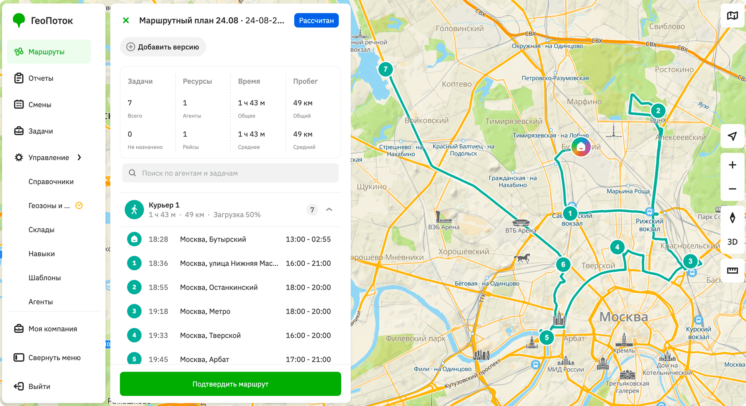
Step 4. Review the result
The dispatcher now has a complete overview: a route for each agent, the order of stops, individual workloads, the number of tasks, and expected completion times. Routes can be adjusted manually whenever needed.
Step 5. Publish the plan
Once the logistician confirms the plan, tasks are automatically sent to the employee applications. Each agent simply starts their shift, opens the first task, navigates to the destination, completes the work, and moves on to the next stop.
How the logistician day changes
The story is usually the same. At first, routes are planned manually in Excel or a CRM. The logistician assigns addresses one by one and spends half the day planning. As order volumes grow, the old approach starts to break down: workloads become uneven, every change means rebuilding the route, and couriers receive assignments through messaging apps.
With Logistics, the day looks different. Calculations take seconds, tasks are assigned automatically, and workloads are distributed evenly. The logistician only needs to review the result and make adjustments when necessary, while assignments go straight to the application, with no message threads or disconnected systems.
There is no longer any need to piece together the full picture across multiple tools. Instead of a scattered set of individual tasks, the logistician has a single route plan. All planning happens in one place, and changes can be handled in minutes rather than forcing the entire day schedule to be rebuilt.
One platform, two ways to work
Logistics calculates routes on the same platform as TSP API. Companies can choose the option that best fits their needs:
- TSP API is the right choice for embedding route planning into an existing system and tailoring it to specific requirements. You can create a demo access key in the Platform Manager.
- 2GIS GeoFlow: Logistics is a ready-to-use product with a logistician interface and an application for agents, requiring no in-house development. Request 14-day demo access or a consultation on this page.
The underlying algorithms are the same. The only difference is whether you use them through an API or as a ready-to-use workspace. There is an option for both development teams and businesses that need to launch quickly.
What's next
The first release is only the beginning. Upcoming updates will include:
- manual route replanning
- automatic addition of urgent tasks while routes are in progress
- task reassignment between agents
- route recalculation after changes
- intelligent assignment of new requests
- machine learning-based arrival time predictions
- detailed analytics and reports
- integrations with enterprise systems
Follow the latest updates in the Logistics documentation.