Examples
Map
To display a simple map without additional objects, specify its size, center, and zoom level.
If there are additional objects on the map, you can omit the center and zoom level, the map will be adjusted automatically.
https://static.maps.2gis.com/2.0?s=880x300&c=55.05888,82.91118&z=15&key=API_KEY
Markers
You can add markers to the map in the shape of circles, pins, or with a custom image. For circles and pins, you can specify the color, size and add numbering.
Embedded styles
By default, the marker is displayed as a small blue pin. In the parameters, you can specify the shape of the marker (circle or pin), one of nine colors, large or small size.
https://static.maps.2gis.com/2.0?s=880x300&pt=55.71433,37.56050~k:p~c:rd~s:s&pt=55.70433,37.57050~k:c~c:gn~s:l&key=API_KEY
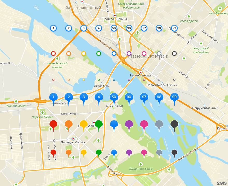
Numbered marker
The marker may be assigned a number from 1 to 99. The number can be assigned both for a pin and for a circle.
You can't set a color or size for a numbered marker.
https://static.maps.2gis.com/2.0?s=880x300&pt=55.71433,37.56050~n:1&pt=55.70433,37.57050~k:c~n:2&key=API_KEY
Custom marker (URL)
You can specify a custom image for the marker using URL.
https://static.maps.2gis.com/2.0?s=880x300&pt=55.70433,37.57050~u:https%3A%2F%2Fimg.icons8.com%2Foffices%2F1x%2Fsound-recording-copyright.png&key=API_KEY
Custom marker (Base64)
The image for the marker can be specified in Base64 format.
https://static.maps.2gis.com/2.0?s=880x300&pt=55.70433,37.57050~b:iVBORw0KGgoAAAANSUhEUgAAAB4AAAAeCAMAAAAM7l6QAAABQVBMVEUAAAAAAP9Pe7lNd7NKe7VQeLdLeLRPfbVOerdMd7NQerVOeLZNerNPe7ROebZPebRPe7ZOebRNebZPe7NOebRNe7VQfLdRe7ZQe7dQfbdPfLhSfrlTf7pTfrlRfrlSf7lSfbhSfrpRfbhRfLdQfbhQfblRfblSfblRfrlSfrlRfrlSfbhQfbdRfbhQfLdQfbdRfblVgbtVgbxXhL5YhL5YhMBZhMBRfbhTgbtUgLtUgbtUgbxXhL9RfbhPe7dPe7ZPe7dpldBqlNBqltFQe7Zpls9pl9BrltBrl9BxnddyntdxndZxnddynddyntd6puB6p%2BF8p%2BF8qOF8qOJ8qeJ8qeN9qOKBreaCrueHtO2ItO2ItO6KtvCLt%2FCOufCQuvGRu%2FGpyvSqyvTG3Pjm7%2Fzv9f3w9f3w9v38%2Ff%2F%2B%2Fv%2F%2F%2F%2F%2BT0lLZAAAAT3RSTlMAAR0eHyAiLS4vMDEyOjs9TU5QUVJTgIGDg4TLy8zNzc7O0ODh4eLk5eXm5%2B3t7u7v8fHx8fHx8vLy8vLy8%2Ff4%2BPj4%2BPn5%2Bfn5%2Bvr7%2B%2Fv790vtUwAAAAFiS0dEaiVilQ4AAAFRSURBVCjPY2AgFnBLKWq6uGjKS3BjyjGKqBm5BURER4cHuFurCqPJsiqZBsfCQZCJAjOyLL%2BuV0wsEojx1edDkjUPi0UDIeZweRa9oFgMEGrABnWVkl8sFuAjB5EWNYHamwUCmWnJ8RD7zYTAmtVgbs6CghSIfKAKSJrHMBYuDSTiEtOzkiF8S06gtJQHinRsbGJWKoTvJgmUVgxAk07IyoDw%2FWWB0toRaNJJMN0RGkBp%2B2hUu5PgdkfbA6UdomKxuzw20g4orRWBIp2ZCvV3bGy4BjanwYG%2FDFBawhmXtJMYUJrLGpe0BTso2FSCsEsHKIOjRBgRJShJwkYAEmUKvtgi1FMamhyY9QKxJAddJlhy4bMNRpcNMudFJDY%2BHU%2FUpOitz4ucVFnkTJAsCDCWZkJL6UIqVq7%2B4cBs4O9opSyIJRNxSspq2tury4pzEJ3vAFWY0vzr8IKOAAAAAElFTkSuQmCC&key=API_KEY

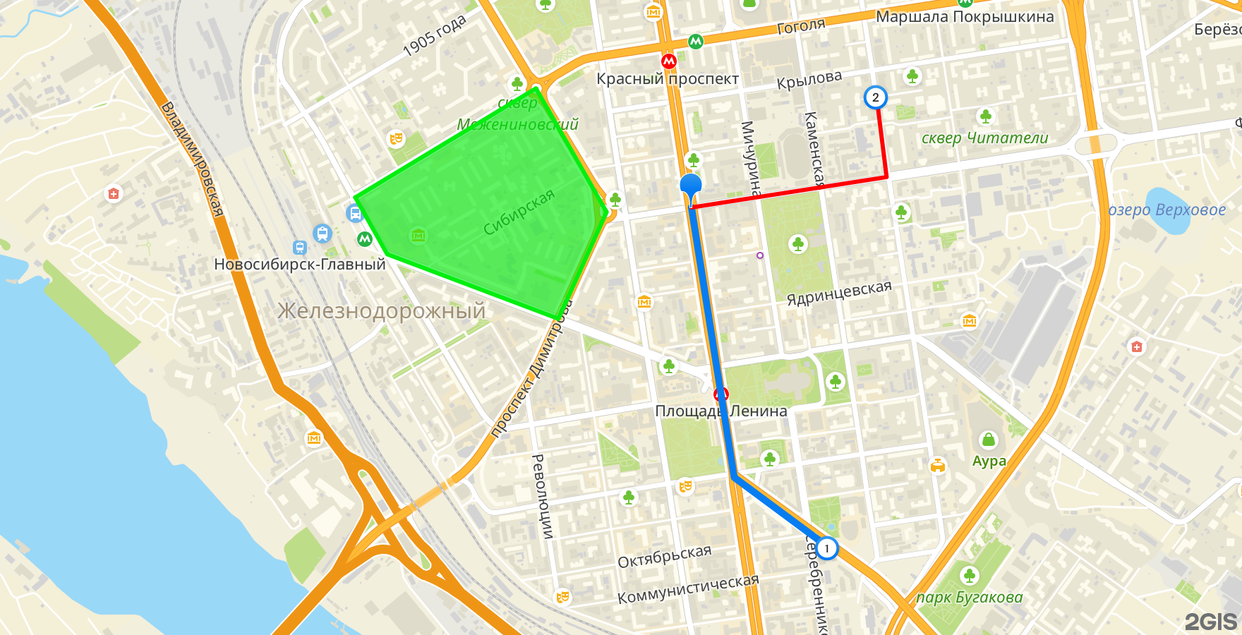
Lines
You can add polylines with the specified color and width to the map.
https://static.maps.2gis.com/2.0?s=880x300&ls=55.73740,37.52284,55.74033,37.53542,55.72481,37.55050~w:5&ls=55.72481,37.55050,55.71790,37.56943,55.72634,37.58097~c:a23fb5~w:5&key=API_KEY
Polygons
You can add polygons to the map with the specified color and width of the outline, as well as the fill color.
https://static.maps.2gis.com/2.0?size=880x300&pn=59.99051,30.19207,59.99284,30.20503,59.98907,30.20292~c:22fe46~f:22fe46a1~w:2&pn=59.99233,30.20822,59.99121,30.21735,59.98738,30.21537,59.98856,30.20592~w:5&pn=59.99054,30.21812,59.98655,30.22571,59.98773,30.21646~c:ed3125~f:ed3125&key=API_KEY
GeoJSON
You can add any objects to the map according to the GeoJSON (RFC 7946) specification and set their style in the properties fields similar to URL parameters.
{
    "type": "FeatureCollection",
    "features": [
        {
            "type": "Feature",
            "geometry": {
                "type": "LineString",
                "coordinates": [
                    [82.91871, 55.03652],
                    [82.92131, 55.02711],
                    [82.92698, 55.0247]
                ]
            },
            "properties": {
                "w": 5
            }
        },
        {
            "type": "Feature",
            "geometry": {
                "type": "Point",
                "coordinates": [82.92698, 55.0247]
            },
            "properties": {
                "k": "c",
                "n": 1
            }
        },
        {
            "type": "Feature",
            "geometry": {
                "type": "Polygon",
                "coordinates": [
                    [
                        [82.89827, 55.03687],
                        [82.90021, 55.03489],
                        [82.91062, 55.03264],
                        [82.91355, 55.03636],
                        [82.90925, 55.04067],
                        [82.89827, 55.03687]
                    ]
                ]
            },
            "properties": {
                "c": "03ee10",
                "f": "03ee10a0"
            }
        }
    ]
}
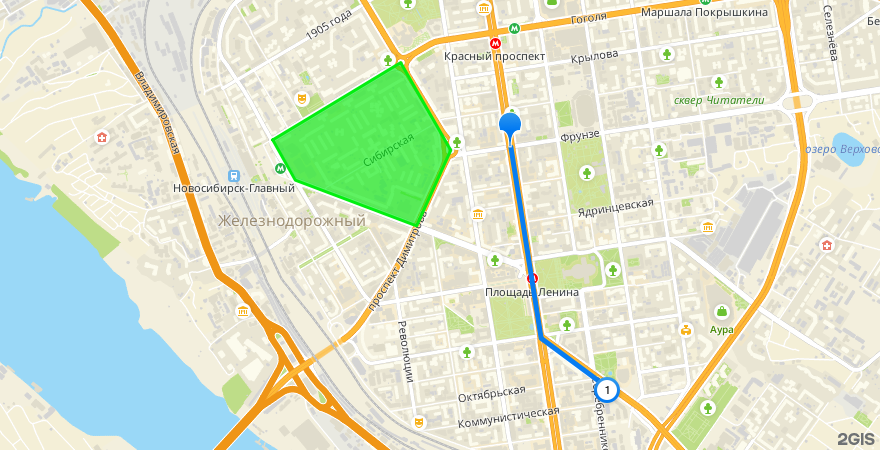
https://static.maps.2gis.com/2.0?s=880x450&z=14&g=%7B%22type%22%3A%22FeatureCollection%22%2C%22features%22%3A%5B%7B%22type%22%3A%22Feature%22%2C%22geometry%22%3A%7B%22type%22%3A%22Point%22%2C%22coordinates%22%3A%5B82.91871%2C55.03652%5D%7D%2C%22properties%22%3Anull%7D%2C%7B%22type%22%3A%22Feature%22%2C%22geometry%22%3A%7B%22type%22%3A%22LineString%22%2C%22coordinates%22%3A%5B%5B82.91871%2C55.03652%5D%2C%5B82.92131%2C55.02711%5D%2C%5B82.92698%2C55.02470%5D%5D%7D%2C%22properties%22%3A%7B%22w%22%3A5%7D%7D%2C%7B%22type%22%3A%22Feature%22%2C%22geometry%22%3A%7B%22type%22%3A%22Point%22%2C%22coordinates%22%3A%5B82.92698%2C55.02470%5D%7D%2C%22properties%22%3A%7B%22k%22%3A%22c%22%2C%22n%22%3A1%7D%7D%2C%7B%22type%22%3A%22Feature%22%2C%22geometry%22%3A%7B%22type%22%3A%22Polygon%22%2C%22coordinates%22%3A%5B%5B%5B82.89827%2C55.03687%5D%2C%5B82.90021%2C55.03489%5D%2C%5B82.91062%2C55.03264%5D%2C%5B82.91355%2C55.03636%5D%2C%5B82.90925%2C55.04067%5D%2C%5B82.89827%2C55.03687%5D%5D%5D%7D%2C%22properties%22%3A%7B%22c%22%3A%2203ee10%22%2C%22f%22%3A%2203ee10a0%22%7D%7D%5D%7D&key=API_KEY
HD & HiDPI
Use HD mode for Retina and other high pixel density displays. In this mode, the map and all its objects, except the custom markers, will be enlarged twice, which will increase the clarity of the image at the same visual size.
https://static.maps.2gis.com/2.0?s=880x450@2x&z=14&pt=55.03652,82.91871&ls=55.03652,82.91871,55.02711,82.92131,55.02470,82.92698~w:5&pt=55.02470,82.92698~k:c~n:1&ls=55.03652,82.91871,55.03758,82.93058,55.04042,82.92996~c:ff0000&pt=55.04042,82.92996~k:c~n:2&pn=55.03687,82.89827,55.04067,82.90925,55.03636,82.91355,55.03264,82.91062,55.03489,82.90021~c:03ee10~f:03ee10a0&pt=55.03484,82.92290~k:c~c:pe&key=API_KEY